
By Nir Hasson | May 27, 2014 | 1:09 PM | Haaretz
Almost since Jerusalem was reunited after the Six-Day War 47 years ago – an event being commemorated today, Jerusalem Day – various ideas have been proposed as to how the city can be redivided. Possible partition lines were drawn during peace talks at Camp David and Taba in 2000-2001, in U.S. President Bill Clinton’s Oval Office and in the bureaus of former Prime Ministers Ehud Barak and Ehud Olmert.
But for the most part, these discussions ended with drawing lines on a map and debate over how to apportion sovereignty to the sites in the area known as the Holy Basin, which includes the Old City and its immediate surroundings.
Very few, if any, sought to figure out whether Jerusalem could actually be divided again – and if so, how would the border look? Would a wall be built in the heart of the city? Where would the crossing points be, and who would be able to use them? What would become of the network of roads and the public transportation system in the area? And so on and so forth.
Click here for the interactive map or see this page.
It is these questions that an Israel-based group of architects headed by Yehuda Greenfield-Gilat and Karen Lee Bar-Sinai have been trying to answer for 10 years now. Decision makers from all the parties concerned are very familiar with their plans. At one meeting between Olmert and Palestinian Authority President Mahmoud Abbas, for example, the Israeli premier presented the architects’ suggestions for a future border crossing between the Sheikh Jarrah and Beit Yisrael neighborhoods in Jerusalem.
About half a year ago, Martin Indyk, America’s special envoy to the Israeli-Palestinian talks, asked to see copies of the firm’s plans. Subsequently, Greenfield-Gilat contacted Finance Minister Yair Lapid and opposition leader MK Isaac Herzog, and also showed them the material.
“I thought it was illogical that the Americans should have this information but not the Israelis,” he says.
 |
| Illustration of the transition to an underground tunnel on Jaffa Road. Photo by Studio SAYA |
Greenfield-Gilat and Bar-Sinai don’t make do with just drawing a border; they address all manner of questions, difficulties and obstacles inherent in a divided city. They offer solutions (albeit not always finalized) to problems involving security, tourism, economic issues, transportation, the function and appearance of border crossings, and more. Their purpose is not necessarily to offer a working blueprint for dividing the city, but merely to prove – first and foremost to the decision makers and the Israeli public – that division is possible. Complicated, expensive and unpleasant, but possible.
“It’s clear that without dividing Jerusalem, there will be no diplomatic agreement,” says attorney Daniel Seidemann, an expert on Jerusalem affairs who has been involved for years in the architects’ project. “But Mayor [Nir] Barkat goes to decision makers and tells them it’s impossible. They can’t deal with this. Suddenly, there are computerized models and you can try to envision how it will look, and this has an extraordinary impact.”
The genesis of this vast undertaking was a final project submitted in 2003 by Greenfield-Gilat, Bar-Sinai and Aya Shapira, at the end of their architecture studies at the Technion-Israel Institute of Technology in Haifa. The project dealt with planning a transportation terminal near the Old City’s Damascus Gate, under the assumption that the city had been divided.
A year later, Shapira was killed in the Indian Ocean tsunami of 2004 while on vacation in Thailand. When Greenfield-Gilat and Bar-Sinai subsequently opened their own firm, they named it after her – SAYA, for “Studio Aya.”
The principle that guided their final project, and to which they have adhered ever since, involved creation of a situation whereby the city’s natural boundaries would become the diplomatic border between countries. Thus, for instance, someone using mass transportation shouldn’t necessarily feel as if he is crossing a formal border; he would simply move between two public transit platforms.
 |
| Architects Yehuda Greenfield-Gilat (left) and Karen Lee Bar-Sinai. Photo by David Bachar |
After they finished their studies, and with encouragement from former minister and “father” of the Oslo Accords, Yossi Beilin, the project was expanded to deal with the entire municipal border, as part of a peace plan prepared by Beilin’s nongovernmental Geneva Initiative. The project was carried out with support from the Economic Cooperation Foundation, a nonprofit Israeli think-tank, and the Washington-based S. Daniel Abraham Center for Middle East Peace. Others involved in the effort were Chen Farkas and Lian Idan-Saga, both now of SAYA, and architect Kobi Ruthenberg.
Green Line as guideline
By 2007, the group had finished most of the plans, and since then, has been striving to improve them. The result: a collection of about 10 thick binders, and hundreds of drawings and computer models that deal with various issues related to dividing Jerusalem.
The principal impression that arises from all these materials, and from conversations with Greenfield-Gilat and Bar-Sinai, is that without question, this is a huge project that will require enormous resources and necessitate far-reaching changes in the city. Nevertheless, the bottom line is that despite 47 years of occupation and settlement, and despite incessant efforts to erase the Green Line in Jerusalem – that line is alive and well, and it’s possible to divide the city more or less along it. Moreover, the life of the average Jerusalem resident won’t need to be affected by the division.
“The decisive majority of Jerusalem residents won’t feel any change in their daily lives,” Greenfield-Gilat explains. “Most of the border will pass through open areas, only five percent of it through urban areas, and only in one place – a 500-meter stretch in Abu Tor – will there be a street with a wall on one side like in Berlin.”
 |
| A rendering of the underground passage under Jaffa Street.Photo by Studio SAYA |
“Some readers will undoubtedly say I’m a delusional leftist, and that will be the end of it,” he says. “But that’s running away from the truth. I’m a Zionist, the son of a family of religious Zionists; I personally observe the religious commandments; and I worry about the future of this city like I do about the future of our children. I have no problem with talking about other plans that safeguard the Zionist interest in Jerusalem. But it’s impossible to keep saying that it’s forbidden to talk about Jerusalem.”
Two main models have been discussed in the past with respect to the potential division of the city, as established in future negotiations. One involves a scheme for an open city, under which Jerusalem would constitute a special entity – a single regime with one municipal government that would nevertheless serve as the capital of both Israel and a Palestinian state simultaneously. The other model is that of a municipal area with a clear, rigid division, with a formal border and border crossings in the heart of the city. Under that model, Jerusalem would essentially turn into two separate cities that function independently, but maintain mutual ties.
According to SAYA’s analysis, the open city model poses many problems. After all, the implication here is that the city will need to be surrounded on all sides by a border. In other words, someone who lived in Jerusalem but worked in Tel Aviv would have to go through a border crossing twice a day and show his passport or other documentation.
“There’s no way a city with almost a million residents could function like that,” Greenfield-Gilat notes.
Thus the model he a
nd Bar-Sinai propose is a mixed one: On one hand, Jerusalem would be divided into two separate municipal entities, but on the other hand, the Old City itself, and perhaps additional areas adjoining it, would have a special status in which neither side would have full sovereignty.
 |
| Illustration of the shape of the barrier in the center of Route 1. Photo by Studio SAYA |
It’s when discussion moves from conference-room maps to the real world – the teeming streets of Jerusalem – that the problems begin, of course. But Greenfield-Gilat and Bar-Sinai believe that most of the new border can be situated along the urban boundaries that exist in Jerusalem, as in any modern city, in any case. All that’s necessary is to link those boundaries and then sharpen them.
The best example of SAYA’s scheme for using “natural” urban boundaries to divide the city is Route 1, also known as Haim Bar-Lev Road. This artery runs along the Green Line from the Old City’s Damascus Gate to the French Hill intersection. It’s a multilane highway divided by the tracks of the light rail and long traffic islands. Thus, the road already constitutes a kind of barrier for any pedestrian seeking to cross over.
According to the architects’ vision, Route 1 would be divided along its entire length. The eastern half would serve the Palestinian population, and the western half, including the light rail train, would serve the Israeli part of the city. The plan also includes a detailed description of the barrier that would be built in the middle of the highway – including a ditch, a fence, gardens, warning signs and cameras. To the pedestrian, it would look like a rather crude traffic island, but not like a threatening border fence.
When the border reaches the vicinity of Damascus Gate, it would move inside a large bus station that could be accessed from both sides of the city. As in the architects’ Technion project, today’s plans show an international border that would turn into a crossing point between two bus platforms. If you want to go to Tel Aviv, you’d stand on the western platform; if you are en route to Ramallah, you’d go to the eastern side.
‘Softening the border’
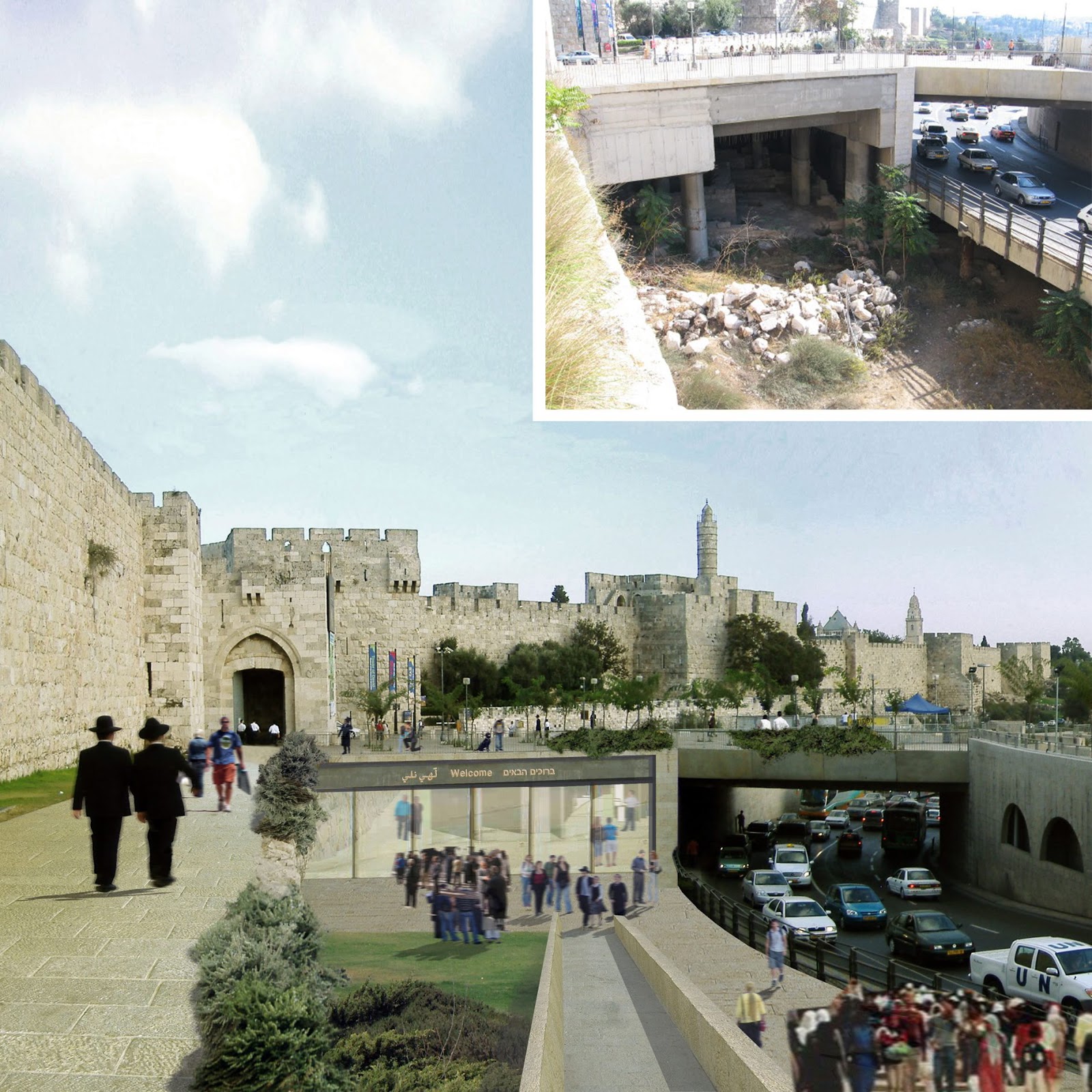
According to the architects, the gates of the Old City would become public border crossings. At Jaffa Gate, they propose two alternatives for the site of the passport control booth. One is at the edge of the Mamilla outdoor shopping mall (Akirov Boulevard). The other is inside a large underground area that was created by archaeological excavations between Akirov Boulevard and Jaffa Gate. The latter scenario involves creation of the passport control booth in an archaeological museum, for the benefit of visitors to the Old City.
One of the thorniest problems faced by the planners is the boundary south of the Old City, in the neighborhood of Abu Tor. This relatively well-to-do area is a unique example of a mixed neighborhood in which the border literally passes between houses. The problem becomes most acute in the area delineated by two roads: Abu Tor Street, which is Palestinian, and most of Ein Rogel Street, which is Israeli. Here, there will be no choice but to build a wall in the heart of a residential area.
But even here, Greenfield-Gilat and Bar-Sinai propose several solutions for softening the border. For instance, it would run along a route that utilizes topographical differences and walls between existing houses, to avoid erecting new barriers insofar as possible. In addition, the architects suggest establishing a kind of promenade along both sides of the future border, thereby treating it almost like a tourist attraction.
“I don’t know whether there will be an agreement [between Israel and the Palestinians], but if there is, this is where the border will run,” says Greenfield-Gilat. “There is no other place. Therefore, we need to take this seriously. More than I’m advocating making an agreement to divide the city, I’m advocating taking this scenario seriously.”
For now, he is not too worried by the expansion of Jewish neighborhoods in East Jerusalem, which periodically outrages various left-wing Israeli organizations as well as the U.S. administration. To the architect who’s dividing the city, the addition of another few dozen housing units in the Gilo or Pisgat Ze’ev neighborhoods is insignificant. The real problems come from small Jewish enclaves in the heart of Palestinian neighborhoods – like, for instance, the huge new yeshiva that’s planned for Sheikh Jarrah. The yeshiva, ironically, is supposed to be located at the very site where the architects planned a border crossing, in the proposal that Olmert showed Abbas.
As noted, more than a few people in Jerusalem, Ramallah and Washington are well acquainted with SAYA’s ideas. When the planners are asked whether they are concerned that revealing the project’s complexity will have the opposite of the desired effect – by causing people to despair of ever effecting a division – they say no.
“In Europe, too, at the end of World War II, people never imagined that Europe would become what it is today,” Bar-Sinai says. “Humanity put a man on the moon; it can also do this.”
“The existing situation is incomparably more conducive to despair,” adds Seidemann. “We’re living in a fictitious city. It’s an Israeli city, but almost 40 percent of its residents have no right to vote. This is a fractured city that is gradually degenerating and imploding.”
“I think about this every day,” says Greenfield-Gilat. “At noon, I have an attack of despair, and in the evening, I take a drink and return to it. Because what’s the alternative? There’s no romantic ride into the sunset with the Palestinians; there’s no such ending. That’s the hard truth. This is the only Zionist possibility if I want to ensure my children’s future in the Jewish state. Go ahead, find me another solution.”
Source: http://www.haaretz.com/news/national/1.595575
No comments:
Post a Comment